1
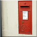
2008 : George V Post Box , Batheaston
On London Road near the road to St. Catherine's Valley.
We know this is a George V box because George VI postboxes were marked "G VI R" in a more ornate style and there were no George IV postboxes.
Image: © Maurice Pullin
Taken: 20 May 2008
0.02 miles
2
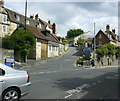
2008 : London Road, Batheaston
Before the coming of the bypass this was the A4 and you would need to be here at about 4 a.m. to see it like this.
OS Explorer 155 indicates a post office. Unseen now it is probably closed. There is still a post box in the wall on the other side of the road and a newsagents just beyond.
Image: © Maurice Pullin
Taken: 20 May 2008
0.02 miles
3
2008 : Looking west on London Road, Batheaston
This is the route of the Fosse Way as it made its way north and east from Bath.
We are at the junction of the minor road to St.Catherine, worth the effort of a walk or a cycle ride.
Image: © Maurice Pullin
Taken: 20 May 2008
0.02 miles
4
High Street, Batheaston
Towards Bath.
Image: © Robin Webster
Taken: 13 Nov 2022
0.03 miles
5
Former chapel, High Street, Batheaston
This is evidently a house now, but with minimal alterations - the roof-lights and perhaps the elaborate hinges on the door under the steeple.
Image: © Humphrey Bolton
Taken: 16 Nov 2010
0.04 miles
6
Former telephone exchange, Fenthouse Hill, Batheaston
My assumption - it is called 'The Old Exchange'.
Image: © Humphrey Bolton
Taken: 16 Nov 2010
0.05 miles
7
2008 : Road to St.Catherine
At the junction with London Road. The Limestone Link follows this valley but does not keep to the road. Care needed if you are driving, narrow, sharp bends and steep in places, better by leg power.
Image: © Maurice Pullin
Taken: 20 May 2008
0.05 miles
8
Ordnance Survey Cut Mark
This OS cut mark can be found on the building at Brow Hill. It marks a point 44.525m above mean sea level.
Image: © Adrian Dust
Taken: 24 May 2024
0.09 miles
9
2008 : The White Hart, Batheaston
The White Hart ("hart" is an old word for stag) was the personal badge of Richard II, who derived it from the arms of his mother, Joan "The Fair Maid of Kent", heiress of Edmund of Woodstock. In the Wilton Diptych (National Gallery, London), which is the earliest authentic contemporary portrait of an English king, Richard II wears a gold and enamelled white hart jewel, and even the angels surrounding the Virgin Mary all wear white hart badges. In English Folklore, the White Hart is associated with Herne the Hunter.
from http://encyclopedia.thefreedictionary.com/white+hart
Image: © Maurice Pullin
Taken: 20 May 2008
0.10 miles
10
Congregational Chapel, Batheaston
Now converted into residential apartments.
Image: © Bill Boaden
Taken: 25 Jul 2016
0.10 miles


