1
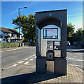
East on Reddicap Heath Road
Buses serve Sutton Coldfield and central Birmingham. A fine oak may speak of a hedgerow past.
Image: © Robin Stott
Taken: 18 Oct 2022
0.03 miles
2
Restaurant, Reddicap Heath
Opposite the shops on Hollyfield Road South "Great Italian Food" from Pesto occupies a former pub, The Bowling Green.
Image: © Robin Stott
Taken: 18 Oct 2022
0.04 miles
3
Reddicap Heath crossroads
Junction of Reddicap Heath Road and Hollyfield Road, opposite shops and car parking
Image: © Graham Flint
Taken: 1 Nov 2006
0.06 miles
4
Crossroads, Reddicap Heath
Reddicap Heath Road, foreground and ahead, crosses Hollyfield Road B4148. There are shops and services around the junction.
Image: © Robin Stott
Taken: 18 Oct 2022
0.06 miles
5
BT phone kiosk, Reddicap Heath
It's by Hollyfield Road South near the shops. Calls may be paid for by cash or card.
Image: © Robin Stott
Taken: 18 Oct 2022
0.07 miles
6
Shops, Reddicap Heath
The shops and services in shot on Hollyfield Road South include a bookmaker, hair salon, vape shop, Subway, fish and chips, car servicing and Co-op Food.
Image: © Robin Stott
Taken: 18 Oct 2022
0.08 miles
7
Suburbia, north Walmley, Sutton Coldfield
Evening view of Walsh Drive, near junction with Tysoe Drive
Image: © Michael Westley
Taken: 15 May 2010
0.11 miles
8
North end of Walmley Road, Sutton Coldfield
Walmley Road runs south for over three kilometres towards Pype Hayes.
Image: © Robin Stott
Taken: 18 Oct 2022
0.12 miles
9
Hollyfield Road South, Reddicap Heath, Sutton Coldfield
Here the north end of Walmley Road peels off northwest while Hollyfield Road South (evocative name) continues B4148 north
Image: © Robin Stott
Taken: 19 Oct 2022
0.13 miles
10
Fairfax School, Sutton Coldfield
On Reddicap Heath Road, near to Fairfax Road http://vle.fairfax.bham.sch.uk/
Image: © Michael Westley
Taken: 15 May 2010
0.13 miles


