1
OS benchmark - Handsworth Wood, 103 Holly Road
An OS cutmark on the side wall of the house; originally levelled, most likely in 1956, at 132.28m above Ordnance Datum Newlyn.
Image: © Richard Law
Taken: 1 Feb 2017
0.02 miles
2
Houses along Holly Road
Rather flash Victorian terraced houses.
Image: © Richard Law
Taken: 1 Feb 2017
0.14 miles
3
OS benchmark - Handsworth Wood, 21 Holly Road
The remains of an OS cutmark on the side wall of the house; originally levelled, probably in 1956, at 124.91m above Ordnance Datum Newlyn.
Image: © Richard Law
Taken: 1 Feb 2017
0.14 miles
4
Lansdowne Road, Gib Heath
This terraced street seems to have avoided the scourge of pavement-parking, by allocating space on the actual road.
Image: © Richard Law
Taken: 1 Feb 2017
0.19 miles
5
Crick Lane, Handsworth Wood
Off Hamstead Road.
Image: © Richard Vince
Taken: 19 Nov 2022
0.20 miles
6
Access road to Penda Court, Handsworth Wood
Off Hamstead Road.
Image: © Richard Vince
Taken: 19 Nov 2022
0.21 miles
7
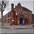
Handsworth Police Station
The police station stands at the corner of Thornhill Road and Golds Hill Road. The architecture suggests the end of the 19th or beginning of the 20th century. POLICE and COURT are carved on the lintel of the porch, and the brackets support a pair of blue lamps - very 'old school'. It is a large building and continues off to the right of the photo.
Image: © A J Paxton
Taken: 22 Apr 2023
0.22 miles
8
Handsworth Mandalas
The mandalas, circular patterns, have been laser-cut into the galvanised steel roof of the Pyramid Tower in Handsworth Park
Image They were designed by Pauline Bailey together with a group of older Bangladeshi women from the locality, who were reflecting on their life journeys as part of a project called Veranda Stories. The tower dates from 2017 and "has a meditative quality to it when standing or sitting underneath and viewing the sky through the patterns in the roof of the pyramid" according to the website of the Handsworth Park Arts Trail https://www.handsworthcreative.com/park-arts-trail .
Image: © A J Paxton
Taken: 3 Sep 2022
0.22 miles
9
Pyramid Tower, Handsworth Park
This galvanised steel tower was designed by the Birmingham artist Pauline Bailey. The mandalas cut into the truncated pyramid roof were designed by Bailey in co-operation with local elders, mainly Bangladeshi women from a sewing group, who expressed their life journeys through these circular patterns as part of a project called Veranda Stories. See the website of Handsworth Creative https://www.handsworthcreative.com/veranda-stories-pyramid-tower .
In the distance can be seen The Sons of Rest Building, erected in the 1930s by a society of retired men.
Image: © A J Paxton
Taken: 3 Sep 2022
0.22 miles
10
Telephone Kiosk on Hampstead Road
This telephone kiosk stands on the west side of Hamstead Road at the junction of Broughton Road. When the photograph was taken the kiosk looked rather neglected and one wonders if its days are numbered.
Image: © Paul Collins
Taken: 8 Nov 2016
0.23 miles


