1
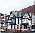
Former public house, Well Street, Birmingham
The former "The Woodman" public house is currently occupied by a wholesale jewellry company.
Image: © Jim Osley
Taken: 27 Apr 2017
0.09 miles
2
Former pub, Well Street, Birmingham
The Woodman closed c2013.
The occupants were Sterling-K which is in the jewellery/souvenir business.
Image: © Stephen Richards
Taken: 22 Jun 2015
0.09 miles
3
Vyse street junction with Great Hampton Street
The brickwork on the building opposite is quite superb. I'd welcome information about its origins and purpose before the groundfloor appearance was spoiled.
Image: © Peter Whatley
Taken: 29 Sep 2008
0.10 miles
4
New John Street West, Newtown
The tower blocks, each of 15 storeys, form part of the St George's Estate and date from the early 1960s. The nearest to the camera is Teviot Tower.
Image: © Stephen McKay
Taken: 17 Mar 2017
0.11 miles
5
Warehouse entrance. Well Street, Birmingham
The building is Grade II listwed: described at this https://historicengland.org.uk/listing/the-list/list-entry/1075542.
Image: © Jim Osley
Taken: 27 Apr 2017
0.12 miles
6
Great Hampton Street
I would welcome more information about the splendid building on the left hand side.
Image: © Peter Whatley
Taken: 29 Sep 2008
0.13 miles
7
The junction of Great Hampton Street and Well Street, Birmingham
This is a Grade II Listed building known as 60-64 Great Hampton Street. Described as a vast works and office block c1912 in the Birmingham Arts and Crafts idiom. I could hardly ignore such a grand building.
Image: © Chris Allen
Taken: 20 Dec 2014
0.13 miles
8
60-64 Great Hampton Street, Birmingham
Making a very loud statement is Crowngate House, built by J.G. Dunn, Dallas & Lloyd in 1913, and extended (to the right) by Dallas & Lloyd in 1919-22. A dizzying combination of brick and terracotta. Grade II listed.
Image: © Stephen Richards
Taken: 22 Jun 2015
0.13 miles
9
Warehouse at the junction of Gt Hampton St & Hockley St
Image: © Row17
Taken: 11 Aug 2010
0.13 miles
10
Site of Midland Bank, Great Hampton Street 40-11-10
I worked for Midland Bank HSBC for 32 years and spent all but the last two in Birmingham Branches. I am photographing all the branches, or what's left of them, as they were when I joined Midland Bank in 1963. The branches all start with the sorting code 40-11.
This is the site of the Great Hampton Street Branch at number 64. The building also housed the Stationery Department from where orders for stationery, placed by local branches, were despatched. The sorting code was 40-11-10.
Image: © Roy Hughes
Taken: 3 Jan 2009
0.13 miles


