Lyddington houses [20]
Introduction
The photograph on this page of Lyddington houses [20] by Michael Dibb as part of the Geograph project.
The Geograph project started in 2005 with the aim of publishing, organising and preserving representative images for every square kilometre of Great Britain, Ireland and the Isle of Man.

There are currently over 7.5m images from over 14,400 individuals and you can help contribute to the project by visiting https://www.geograph.org.uk
Lyddington houses [20]
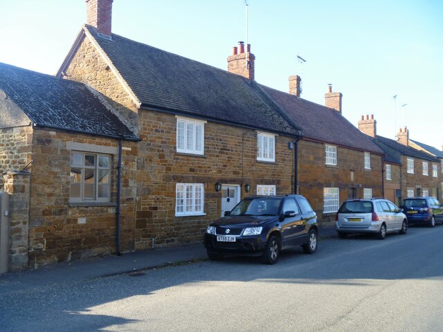
Image: © Michael Dibb Taken: 26 Sep 2021
Number 61 Main Street, nearer the camera, was built in the early 19th century of coursed ironstone rubble stone under a concrete tile roof. Listed, for group value, grade II, with details at: https://historicengland.org.uk/listing/the-list/list-entry/1236840 Number 63 Main Street is dated 1763 and has been heightened in the 20th century. Constructed of ironstone ashlar under a concrete tile roof. Listed, grade II, with details at: https://historicengland.org.uk/listing/the-list/list-entry/1236841 Lyddington is a pretty rural village in the county of Rutland, some 20 miles east of Peterborough and 18 miles southeast of Leicester. The village stretches out in a linear fashion over a mile with cottages of reddish limestone arranged on either side of the main road. The village is home to the Bede House, the remains of a medieval Bishop's Palace.
Images are licensed for reuse under creativecommons.org/licenses/by-sa/2.0
Image Location


Leaflet Map data © OpenStreetMap
Latitude
52.56525
Longitude
-0.711139