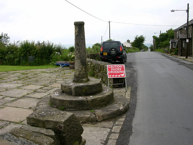
Affetside Cross
Introduction
The photograph on this page of Affetside Cross by liz dawson as part of the Geograph project.
The Geograph project started in 2005 with the aim of publishing, organising and preserving representative images for every square kilometre of Great Britain, Ireland and the Isle of Man.
There are currently over 7.5m images from over 14,400 individuals and you can help contribute to the project by visiting https://www.geograph.org.uk

Image: © liz dawson Taken: 16 Jun 2007
Affetside Cross has always prompted questions from people intrigued as to its history. In fact one curious person, believing it concealed hidden treasure, actually pulled it up late one night in the 1890s. However he was to be disappointed, finding nothing, not even a single Roman coin. Fortunately the Roman cross was repaired by the Lord of the Manor and still stands today marking the supposed half way point between London and Edinburgh. Affetside cross still remains a mystery today; thought to date from medieval times and perhaps much earlier. Its close proximity to the Roman road from Manchester Mamucium to Ribchester Bremetenacum has caused many to mistakenly date it as Roman in origin and yet some date it much later. Present thinking considers it as a medieval route marker for Lancashire pilgrims on route to Whalley Abbey. Some see it as a market cross from Jacobean or Georgian times or it may mark the point of a beacon due to its dominant position. The view which holds it is a market cross does not, on the surface, appear to make much sense as Affetside has had no record of ever having a market charter (although it is recognised that many markets did exist throughout Lancashire without a charter ever being granted), and as a market it would have been difficult to access in addition to being very remote and as such would have suffered from competition from adjacent areas with greater populations. The loss of the cross head is undated and furthermore it has never been proven that it ever had one. The Cross is a listed grade II structure. The cross shaft is cut from a single piece of local gritstone, set into a plinth of 2 stones on 2 steps. The first step is circular, 2.28 m (7.5 ft) in diameter, and 0.1 m (4 inches) high. The second step is 1.6 m (5 ft 3 inches) in diameter, and 0.25 m (10 inches) high. The shaft is of a pillar form with a square base 0.34 m (1 ft) wide tapering to a column 1.43 m (4 ft 8 inches) high. At 1.34m (4 ft 4 inches) there is a collar surmounted by a bun shaped capital. Cut into the top is a socket that probably held the cross head or stone ball. There are other pilgrims crosses in the area, notably Holcombe Moor to the east, and at Bradshaw, (which has now been removed) and the Pilgrims Cross theory appears to be the most plausible, as the route east to west was an old packhorse trail and was a major route for the passage of goods and people.

